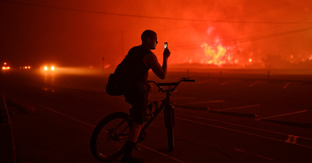
Fast-moving fires on Tuesday forced more than 30,000 people in the Los Angeles area to evacuate their homes, as the skies turned red and fierce winds knocked down trees and power lines.
The wind storm was expected to bring even more destruction overnight and into Wednesday. The two large fires — one in the Pacific Palisades and the other in the mountains above Pasadena — were not at all contained as of Tuesday night and the winds were forecast to reach as high as 100 miles per hour, the strongest Southern California has experienced in more than a decade.
Here’s the latest on the blazes:
Where are the fires burning?
The fires were burning on opposite sides of the Los Angeles area. To the west, the Palisades fire had burned more than 2,900 acres in Pacific Palisades, a coastal neighborhood west of downtown Los Angeles. The fire had spread quickly throughout Tuesday. In the afternoon, the fire more than doubled in size in a matter of about three hours.
To the east, another fire began in the evening in Eaton Canyon, in the San Gabriel Mountains above Altadena. The blaze, which was being called the Eaton fire, had consumed 400 acres in a couple of hours.
And to the north, the Hurst fire quickly grew to 100 acres and forced evacuations in Sylmar, a suburb in the San Fernando Valley northwest of downtown Los Angeles.
How many homes have been destroyed?
Kristin M. Crowley, fire chief of the Los Angeles Fire Department, said on Tuesday afternoon that multiple structures had been damaged in Pacific Palisades, but it was unclear exactly how many homes or buildings had been damaged from either fire.
In the area of the Palisades fire, officials said that more than 10,000 households and about 13,000 structures were under threat.
At least 550 homes were threatened by the Eaton fire, said Lisa Derderian, a Pasadena spokeswoman.
Why did these big fires break out at the same time?
Forecasters this week had warned of damaging wind gusts that would reach 50 to 80 m.p.h., and even above 100 m.p.h. in the mountains. The winds, combined with dry air, have created a critical fire-weather event in Southern California. The hills are also covered in vegetation after two rainy winters that preceded this one. “This is about as bad as it gets in terms of fire weather,” forecasters said.
The winter and late fall tend to spawn catastrophic fires in California.
In periods without significant precipitation, as has been the case this winter, the vegetation becomes extremely parched. And cooler weather in California coincides with the Santa Ana winds, the strong and dry gusts that blow west from Nevada and Utah to Southern California — and are linked to the region’s most devastating fires.
The deadliest and most destructive fire in California’s history, which destroyed the Northern California town of Paradise, broke out in mid-November 2018.
Are the fires expected to keep growing on Wednesday?
Unfortunately, yes. Firefighters were limited to battling the blazes from the ground on Tuesday night, as aircraft were grounded because of the strong winds, and both fires were not at all contained.
The winds were expected to peak between 10 p.m. local time Tuesday and 5 a.m. on Wednesday, conditions that could cause the fires to balloon rapidly. Though the winds are expected to begin diminishing on Wednesday afternoon, they will be moderately strong in Los Angeles and Ventura counties through Thursday, according to weather officials.
Fire officials are asking people who have not yet evacuated but live near the fires to stay alert, as the blazes will likely move fast and unpredictably in the coming hours. And they are asking everyone in Southern California to beware of new fires.


