


Residents on Western Australia’s north coast are bracing for impact as Tropical Cyclone Narelle — which has been upgraded to category 4 — regains strength and bears down on coastal communities.
Areas between Port Hedland and Northampton, including Karratha, Onslow, Exmouth, Coral Bay, Carnarvon, and Denham, and to Pannawonica and Murchison to the east are all on alert
“There is a threat to lives and homes. You are in danger and need to act immediately,” the Department of Fire and Emergency Services said in a statement.


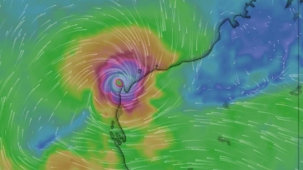
Speaking in the National Situation Room on Thursday morning, Bureau of Meteorology spokeswoman Jessica Roussell said Narelle was sitting off the coast of WA and would continue to grow in severity.
“It will continue to strengthen today into a category four system as it tracks parallel to the Pilbrara coast. From tomorrow, the system will start to turn to the south,” Ms Roussell said. “It will pass close to the northwest Cape as a category 4, possibly even a category 5 system. A coastal crossing is likely on Friday or Saturday, however the exact location and timing of the crossing all depend on how quickly the system begins to turn,” she said.
Ms Roussell said communities in the area could expect to see “dangerous storm tides” on Friday, particularly between Exmouth and Denham, as well as heavy rainfalls between 50 and 100 millimetres.
“Strong winds associated with the system are being felt currently along the Pilbara coastline, and will pick up today around the Karratha to Exmouth region, with gusts of up to 125 kilometres an hour possible,” she said. “From Friday, this risk will extend further south to Denham and Carnarvon, with wind gusts of 195 to 220km/h possible. While the system is very unlikely to track as far south as Perth as a tropical cyclone, Perth could still see heavy rainfall in the range of 50 to 100 millimetres on Friday and Saturday.”


Unusual path puts WA in firing line
Meteorologists said the system’s projected path down the WA coast was unusual but not unprecedented, with past cyclones bringing damaging winds and flooding as far south as Perth.
If Narelle makes landfall as a tropical cyclone in WA, it would mark a rare third cyclone-strength crossing across Australia after already hitting Queensland and the Northern Territory.
Only two other systems in more than four decades, Cyclones Ingrid (2005) and Steve (2000), have achieved this in modern records.
With several days of dangerous weather ahead and the track still subject to change, authorities are urging residents across the Kimberley, Pilbara and western WA to monitor warnings closely as Narelle continues to intensify.
https://thewest.com.au/news/tropical-cyclone-narelle-bears-down-on-wa-coast-residents-warned-to-act-c-22055190


