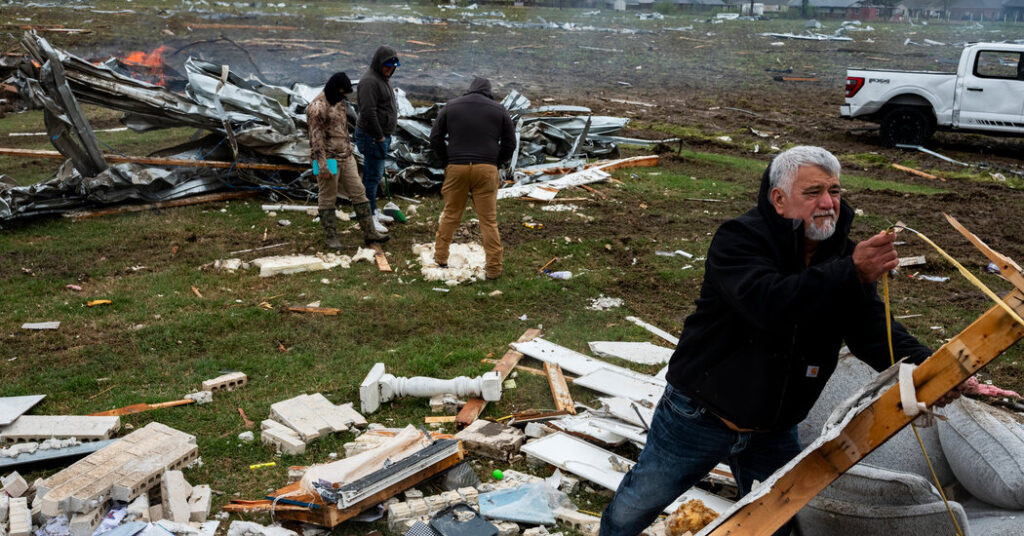
Residents across the South and Midwest woke up on Friday to more heavy rain, as a relentless storm that has already spawned over 30 tornadoes and killed at least seven people continued to wreak havoc.
From Arkansas to Michigan, communities were on high alert for more potentially dangerous flooding as they sifted through the debris left by the heavy rainfall and high-speed winds that started Wednesday night. Residents of river towns and cities were eyeing rising waters and piling up sandbags in anticipation of more rain this weekend.
Wet weather is expected to be widespread on Friday across a portion of the central United States, from eastern Texas to Illinois. The National Weather Service warned Friday morning of a “life-threatening, catastrophic” flash flood event across the Lower Ohio Valley and the Mid-South to Lower Mississippi Valley, and a flash flood warning was in effect for much of central and western Kentucky.
In Boston, Ky., roughly 35 miles south of Louisville, Bruce Gooden could see the water creeping up on Friday as he cut hair at his barbershop near Lick Creek. The creek was engorged because water could not flow into the nearby Rolling Fork River, which was already above flood stage.
Mr. Gooden had seen the water rise before, but the unrelenting rainfall and cracking lightning fed a sense of doom.
“The water has never made it into my shop before, but I fear it will happen this time,” Mr. Gooden, 63, said as he kept clipping. He said he had sand piled in the bed of his truck, and he was ready to bag it if need be.
“I’ll play it by ear. I’ll stay open as long as I can,” he said. “I hope I don’t have to do the sandbagging thing, but I probably will.”
On Friday, the bull’s-eye for the heaviest rain that could lead to dangerous flooding falls within a large portion of Arkansas and a sliver of southern Missouri, including the Ozarks. On Saturday, the threat is expected to spread into the boot heel of Missouri and western Kentucky and Tennessee.
Flooding is expected on roads, and major rivers will probably spill over their banks, as the already saturated ground will not be able to absorb several more inches of rain.
“I think unfortunately the next 24 to 36 hours is when we’re going to start to see the heaviest rain totals of this event, and the number of flooding occurrences are going to go up,” Frank Pereira, a meteorologist with the Weather Prediction Center, said. “I’m actually quite concerned.”
In the same general area under a threat of flooding, there’s also a possibility of severe thunderstorms spawning tornadoes on Friday.
That risk will bump up on Saturday, especially from the Sabine River Valley to the northeast, into the lower to mid-Mississippi and Ohio Valleys. Memphis; Little Rock, Ark.; and Jackson, Miss., all fall within this zone. Powerful and damaging wind gusts and large hailstones — perhaps bigger than limes — are more likely in this area than are tornadoes.
In Tennessee, where at least five people, including a teenage girl, were killed by the storms, several inches of rainfall throughout Thursday caused major floods and shut down roadways.
In a news conference Thursday night, Gov. Bill Lee warned residents that the dangers posed by the storm were potent and could intensify. “The main message tonight,” he said, “is don’t let your guard down.”
The other people who died in the storms included a fire chief from Missouri and a 27-year-old man from Indiana.
In East Cape Girardeau, Ill., Randy Colyer and his family took shelter overnight, as winds swept across their farmland. “We went in the basement and heard noises — loud noises — and then we came out and just started looking around,” Mr. Colyer said. A shed was gone and the farmhouse was damaged, along with much of his equipment, including tractors and combines.
In New Madrid, Mo., a city along the Mississippi River and one of many river communities at risk of rising water levels, the U.S. Army Corps of Engineers brought the city sandbag-filling machines to help prepare for any flooding. In Arkansas, participants in a Corrections Department work-release program helped fill sandbags in Saline County.
As people made preparations, anxiety among customers at Boston Food Mart in Boston, Ky., seemed to be rising as gradually as the water. For now, they seemed to be taking their worries in stride.
“You have to be ahead of it and aware of it, make plans,” said Steve Fox, 68, whose house is on a hill nearby, high up enough that he believes he is safe from flooding. But the hill could become an island, he said, if the water rises enough. That’s why he was at the store gathering supplies.
“The water will probably get over the roads, and I’ll be cut off for a few days,” Mr. Fox said.
For those around long enough to remember, a flood in 1997 — one of the deadliest disasters in Kentucky history — is the yardstick against which events like this are measured, and residents fear the coming hours and days could bring something comparable.
Denise Baker has worked at the Food Mart for 31 years, 20 of them as manager. In all that time, floodwater had never breached her store, but she knew that was no guarantee that it would not happen this time.
She knows how much the community relies on the store, and she was determined to maintain that lifeline — even if the store were to become accessible only by boat.
“We’re going to try to keep the store open as long as possible,” Ms. Baker said.
Carly Gist, Jenny Gross, Mitch Smith and Sara Ruberg contributed reporting.
https://www.nytimes.com/2025/04/04/us/severe-storms-central-united-states.html


