


Scientists spent the first weeks of the year on an expedition to Antarctica to study Thwaites Glacier, which is melting at an alarming rate. If it breaks apart entirely, it could push up global sea levels by two feet over the course of several decades, affecting tens of millions worldwide, according to a New York Times analysis.
The maps below show some of the coastal cities at risk and populated, low-lying areas that could be threatened if the glacier were to collapse today.
1.7 million
These are just the minimum effects that Thwaites’s disintegration would be likely to have on the world’s coastlines. As the glacier breaks apart, global warming will raise sea levels even higher by melting the ice from Greenland and causing oceans to expand in volume. And Thwaites acts as a plug, holding back many of the Antarctic glaciers on land around it. If it collapses, they could break apart and spill into the sea as well.
“Eventually it would take out all of the West Antarctic,” said Richard Alley, a professor of geosciences at Penn State.
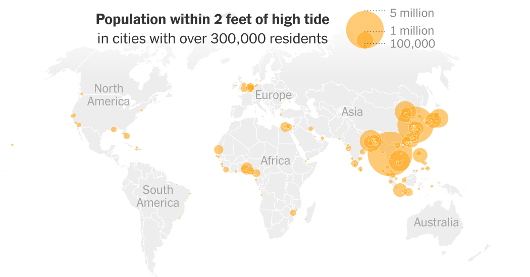
Seaside cities all over the world are at risk, but the threat is especially acute in Asia, and includes some of the world’s fastest-growing urban areas, as the map below shows:
The costs of guarding against higher storm surges and more frequent flooding would be huge. One proposal from the U.S. Army Corps of Engineers to protect parts of New York City would cost more than $52 billion, a price tag that would be out of reach for much of the world.
“We’ll defend the highest-value places that are defensible, but there will be other places that we don’t,” said Benjamin Strauss, Chief Scientist at Climate Central, a nonprofit science organization that produced the elevation models used in this article.
In city after city, the Times’s analysis found that heavily populated areas tend to be near the coasts, as opposed to higher, safer areas.
Shanghai, one of the major cities under threat, already has more than 600,000 residents living below sea level. If average sea levels rose two feet, an additional 4.7 million people would be affected.
Shanghai’s population at each elevation
Like many of the most vulnerable places, Shanghai is situated on a soft, marshy delta, a landscape naturally prone to sinking, although humans often speed up the process by building structures and draining the groundwater below. The city has also been adding and reinforcing seawalls, and replacing concrete with wetland parks to absorb stormwater.
For places like Shanghai, the cost of defending the city is relatively modest compared with its value, said Jochen Hinkel, director of the Global Climate Forum, an international research organization based in Germany. “There’s so much capital concentrated on a small piece of land,” he said.
But not all places have the resources to protect themselves. Dhaka, the capital of Bangladesh, is expected to swell to over 50 million people by 2050, and will rely extensively on borrowed money to prepare for the worst.
Dhaka’s population at each elevation
Bangladesh, a low-lying delta nation, is experiencing more volatile monsoons and stronger cyclones as the planet warms. Villages have already been erased as the tides rise and rivers in the region change shape. Saltwater tides have ruined farmland, driving rural residents to the already-crowded capital.
The limits to adaptation
In the United States, a two-foot increase in sea levels wouldn’t affect as many people as in parts of Asia, but the price of adaptation would be astronomical. And even in the wealthiest country in the world, flood defenses aren’t bulletproof.
When the network of pumps and levees failed during Hurricane Katrina in 2005, the catastrophe killed 1,400 people and displaced more than a million. Recovery in New Orleans has cost about $140 billion. Dozens of smaller communities along the Gulf Coast may not be so lucky.
120,000 people within 2 feet of high tide


Areas protected
by levees
125,000
Coastal cities elsewhere are bracing for higher sea levels. It would cost $13.6 billion to shield part of the San Francisco waterfront. Farther inland in California, it would take $2 billion to improve protections in Stockton. Across the country, a giant barrier at New York City’s harbor could cost $119 billion.
Yet people and buildings continue to accumulate in harm’s way. Miami’s population and real estate values have exploded in recent years, despite the fact that the city is notoriously difficult to protect.
Clearer answers about if, and when, Thwaites could collapse may make all the difference in how well coastal areas are able to adapt. “The value of the information is grotesquely higher than what we’ve invested in it,” Dr. Alley said.
Under President Trump, the United States has abandoned research that could better forecast the effects of Antarctica’s melting ice. It has also promoted the use and burning of fossil fuels, adding to the greenhouse gas emissions that are dangerously heating the planet. That could speed up the glacier’s collapse.
The fallout from decisions made today may not be felt immediately, Dr. Strauss said, but “this is what we’re signing up the future for.”
Methodology
The Times’s analysis includes cities with 300,000 residents or more and within 100 miles of the coast.
It used elevation data from Climate Central’s CoastalDEM 3.0 to calculate the average high tides at each location. This model reflects local water levels more accurately than global averages. It used data from the European Commission’s Global Human Settlement Layer (GHS-UCDB) for city boundaries and Worldpop’s 2026 data for population estimates.
The sea level rise scenarios in this article focus only on the effects from Antarctica. The continent is expected to lose its gravitational pull on ocean water as it loses ice. As that happens, parts of the Northern Hemisphere, including the United States and much of Asia, will experience higher-than-average effects in sea level rise than places closer to Antarctica.
The maps and total population numbers are adjusted to reflect this dynamic, using data from Jerry Mitrovica, professor of geophysics at Harvard. They do not account for similar dynamics from Greenland’s ice loss, or for any other influences that may cause an uneven distribution of sea level rise.
https://www.nytimes.com/interactive/2026/03/17/climate/thwaites-glacier-rising-sea-level-risk-floods.html


