
In Summary
- Africa’s top urbanized nations are redefining growth, showing that city planning now drives economic and administrative efficiency.
- Coastal and mid-sized cities are anchoring industrial, service, and logistics hubs, not just population centers.
- Smaller states are converting dense urban populations into high-functioning infrastructure, digital governance, and industrial advantage.
Deep Dive!!
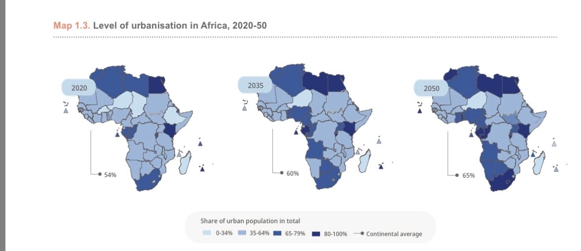
Lagos, Nigeria, Wednesday, October 15 – Urbanization has become one of Africa’s most transformative realities. In 1950, less than 15% of Africans lived in cities but by 2025, that share is approaching 50%, and projected to exceed 60% by 2050. The shift is being driven not only by population growth but by decades of policy adaptation, land reform, decentralization, housing development, and infrastructure expansion.
Across the continent, national planning has gradually moved from rural subsistence concerns toward managing density, employment, and service delivery in rapidly expanding cities.
The countries leading in urbanization represent diverse governance systems and economic foundations. In resource-dependent states like Gabon, Libya, and Equatorial Guinea, the early centralization of oil wealth created urban economies long before diversification efforts began.
In others, such as Tunisia and Botswana, consistent spatial planning, industrial policy, and investment in urban governance have helped cities absorb migration without collapsing public systems. This diversity shows that Africa’s urban growth is not uniform; it reflects varying levels of state capacity, institutional maturity, and the balance between extractive and productive sectors.
This ranking based on the latest available data for each country presents Africa’s ten most urbanized nations as of early 2025. It examines how urban concentration now functions as an indicator of administrative efficiency, economic structure, and political stability.
More importantly, it highlights how several smaller and mid-sized states have turned high urbanization into an advantage by improving access to education, healthcare, and digital infrastructure while gradually reforming housing and transport. Africa’s next economic phase will be defined less by how fast its cities grow, and more by how effectively governments translate that growth into organized, livable, and productive environments.
10. Angola
Angola’s urbanization rate stands at 69.28%, placing it among Africa’s most urbanized nations. This concentration is largely a legacy of post-independence migration and reconstruction, as well as recent diversification of the non-oil economy. Luanda, home to over eight million people, remains the country’s economic nucleus, but medium-sized cities such as Huambo, Lubango, Benguela, and Lobito are now absorbing significant population growth due to infrastructure expansion and regional industrialization projects. The completion of major road corridors linking the coast to the interior, particularly the Benguela Railway, has gradually rebalanced urban density away from Luanda’s periphery.
Urbanization in Angola has historically reflected state policy rather than spontaneous settlement. Following decades of internal displacement during the civil war, the government adopted a centralized urban management model anchored on reconstruction zones and provincial capitals. In the past decade, policy direction has shifted toward spatial redistribution. The National Urbanization and Housing Policy, renewed in 2021, emphasizes affordable housing, integrated city planning, and alignment of urban growth with economic corridors like Lobito and Huambo. Foreign partnerships, particularly with Brazil, China, and Portugal, have strengthened Angola’s construction and public works sector, driving both housing stock and employment in urban centers.
Efforts to organize urban expansion are visible across several fronts. The Centrality Projects planned satellite towns in Luanda, Kilamba, and Zango reflect a deliberate attempt to structure migration and improve living standards through serviced housing and infrastructure provision. The government has also begun promoting “intermediate cities” to decentralize investment, using tax incentives and public–private partnerships to attract industries inland. Meanwhile, Luanda’s ongoing modernization supported by a metro system project, upgraded port facilities, and urban sanitation investments illustrates how Angola is transforming its postwar reconstruction phase into a long-term model of managed urban growth. Urbanization in Angola today is not merely demographic; it is strategic, reflecting a clear national objective to align spatial planning with economic diversification.
9. South Africa
South Africa’s urbanization rate is 69.3% according to the latest available figures, placing it firmly within the continent’s most urbanized group. Urban populations are concentrated in the country’s eight metropolitan municipalities, with Gauteng alone accounting for the largest share of metropolitan residents. Major urban centres Johannesburg, Cape Town, eThekwini (Durban), Tshwane (Pretoria), and Nelson Mandela Bay function as national economic anchors, together generating a disproportionate share of GDP, formal employment, and service-sector activity relative to their population size. The metropolitan structure gives South Africa an urban profile that is both dense and institutionally layered.
Urban form and policy in South Africa reflect long-standing planning institutions and a mature municipal governance architecture. Metropolitan municipalities have financial autonomy, credit access via municipal bonds, and multi-year Integrated Development Plans (IDPs) that steer capital investment. The Spatial Planning and Land Use Management Act (SPLUMA) has provided a uniform legal framework for zoning and development control since 2013, enabling more predictable land release and cross-jurisdictional planning. Transport investments such as the Gautrain rapid rail, Cape Town’s MyCiTi bus system, and Johannesburg’s Rea Vaya BRT are examples of cities sequencing mobility projects to support densification and corridor development. On the private side, inner-city regeneration projects typified by precinct renewals in Johannesburg’s Maboneng and Cape Town’s Foreshore and central business precincts demonstrate how market actors and municipalities coordinate to convert underutilized urban parcels into mixed-use nodes. These institutional and market processes explain why high urbanization in South Africa translates into complex, functional metropolitan systems rather than mere population agglomeration.
Recent policy and investment shifts underline a deliberate push to leverage urban concentration for productivity and inclusion. National and provincial programs are scaling municipal creditworthiness improvements and performance-based transfers to accelerate bulk infrastructure provision and informal settlement upgrades. Cities are using Special Economic Zones and port-linked industrial precincts notably the Coega SEZ and related logistics investments to connect urban labour pools with manufacturing and export platforms. At the municipal level, targeted land-release strategies, increased use of value-capture financing, and partnerships with pension funds and private developers are widening the pipeline for affordable rental and sectional title housing in high-employment corridors. These measures, pursued within an established metropolitan governance framework, show how South Africa’s high urbanization rate is being operationalised into structured urban investment and spatial transformation.
8. Republic of the Congo
The Republic of the Congo records an urbanization rate of 69.64%, one of the highest in Central Africa. Urban concentration is dominated by two cities Brazzaville, the political and administrative capital, and Pointe-Noire, the commercial and oil hub. Together, they account for more than half of the country’s population. Brazzaville has historically been the heart of state governance and education, while Pointe-Noire’s growth accelerated with offshore oil exploitation and port development. Secondary towns such as Dolisie, Nkayi, and Oyo are now absorbing steady inflows of people, supported by ongoing transport and housing investments that seek to balance national spatial development.
Congo’s urban structure reflects decades of deliberate planning shaped by oil revenues and state-led modernization. Since the 1980s, national development strategies have prioritized urban services, public housing, and road connectivity as instruments of social stability. The government’s Vision Congo 2025 plan identifies cities as engines of economic diversification, focusing on logistics, construction materials, and food processing as growth sectors. Brazzaville’s modernization drive especially through the expansion of the Talangai industrial zone and the construction of the Kintélé administrative city has improved the provision of government and business infrastructure. In Pointe-Noire, continued upgrades to the port and its hinterland railway have deepened the city’s role as a transit and export hub for Central Africa, linking Congo with Gabon, Cameroon, and the Democratic Republic of Congo.
Urban governance reform is now central to Congo’s national agenda. The National Urban Policy, introduced in cooperation with UN-Habitat, focuses on improving land management, digitizing property records, and creating sustainable housing frameworks to regulate informal expansion. Major housing projects, such as the Mpila and Kintélé estates, demonstrate the state’s ongoing investment in structured settlements. Public–private partnerships are being mobilized for road rehabilitation and waste management, while international funding supports climate-resilient urban planning and flood control in Brazzaville’s low-lying districts. Congo’s approach to urbanization is pragmatic, anchored in infrastructure, institutional renewal, and strategic spatial planning aimed at turning urban density into an organized development asset rather than a demographic challenge.
7. Tunisia
Tunisia’s urbanization rate of 70.88% places it among North Africa’s most structurally organized and spatially balanced nations. Urban populations are concentrated along the coastal belt, stretching from the capital Tunis through Sousse, Sfax, and Bizerte. Unlike many African countries where a single megacity dominates, Tunisia’s urban network is polycentric supported by mid-sized towns that function as regional economic hubs. This spatial balance has allowed Tunisia to sustain high service delivery levels while managing internal migration effectively. The Greater Tunis metropolitan area, which houses roughly a quarter of the national population, anchors the country’s financial, administrative, and industrial systems.
Tunisia’s urban structure reflects decades of state-led planning rooted in institutional continuity. The Ministry of Equipment, Housing, and Spatial Planning has maintained a centralized approach to land management, enforcing zoning codes and urban design standards that ensure long-term spatial coherence. Industrial and technology parks in Sousse, Sfax, and El Ghazala illustrate how Tunisia links urban expansion to production and innovation rather than uncontrolled population growth. The government’s strong municipal framework supported by fiscal transfers and local revenue generation has helped cities maintain functional infrastructure and reliable public transport systems. Moreover, post-2011 decentralization laws have progressively shifted more planning responsibilities to regional and local authorities, strengthening urban governance capacity across the interior.
Urban reform in Tunisia is now focused on resilience, sustainability, and digital transition. The Smart Tunisia Initiative and National Urban Strategy 2050 aim to integrate technology into municipal management, promote renewable energy use in public facilities, and modernize waste collection systems. Ongoing housing programs emphasize affordability and densification near employment centers, while public investments continue to expand urban transport corridors linking coastal and inland cities. Tunisia’s experience demonstrates that sustained policy discipline and planning continuity can transform high urbanization into organized growth, reinforcing social stability and economic diversification. The country’s urban profile today reflects a rare equilibrium in Africa where demographic concentration, institutional capacity, and long-term governance align within a single development framework.
6. Botswana
Botswana’s urbanization rate of 73.49% stands as one of the highest in Southern Africa, marking a remarkable evolution for a country that was largely rural at independence in 1966. The capital, Gaborone, now exceeds 400,000 residents, but Botswana’s urbanization is distributed across a network of well-planned secondary towns Francistown, Maun, Selebi-Phikwe, Lobatse, and Jwaneng each integrated into national economic corridors. This dispersion has helped avoid the dominance of a single megacity while ensuring that urban growth supports national productivity. High internal migration toward mining towns and administrative centers, coupled with consistent investment in housing, utilities, and industrial zones, has consolidated Botswana’s status as one of Africa’s most orderly urbanizing nations.
Botswana’s approach to urban development is rooted in deliberate policy continuity. The country’s National Settlement Policy, first introduced in 1978 and periodically updated, remains the guiding framework for spatial planning. It prioritizes balanced urban expansion and equitable access to infrastructure across all regions. Municipal planning authorities operate under the oversight of the Ministry of Local Government and Rural Development, ensuring coordination between local and national plans. Industrial development zones near Gaborone and Francistown, especially those aligned with the Trans-Kalahari Corridor illustrate how urban planning and trade facilitation are jointly pursued. The result is a spatially structured system where cities grow around economic functions rather than spontaneous population clustering.
Reform efforts continue to focus on sustainability, digital governance, and housing affordability. The government’s National Housing Policy (2021–2030) seeks to reduce urban housing deficits by promoting serviced plots, mortgage access, and partnerships with private developers. Infrastructure projects such as the Greater Gaborone Water and Sanitation Program and solar energy installations in peri-urban areas reinforce Botswana’s commitment to service reliability. The introduction of e-planning systems has improved building permit processing and land registration, making Botswana one of the most administratively efficient urban systems in sub-Saharan Africa. Its urbanization story reflects the outcome of institutional stability, strategic foresight, and long-term investment in governance capacity turning high urban concentration into a managed and sustainable development model.
5. Equatorial Guinea
Equatorial Guinea’s urbanization rate of 74.87% makes it one of Africa’s most city-centered nations. Despite its small population, just over 1.6 million urban residents dominate both the mainland region of Río Muni and the island province of Bioko. The capital, Malabo, and the newer administrative city of Oyala (now called Ciudad de la Paz) illustrate the country’s dual urban model: one coastal and historical, the other purpose-built and strategic. Bata, the largest city on the mainland, serves as the commercial hub, supported by port infrastructure and manufacturing activity. High urbanization in Equatorial Guinea is thus the product of deliberate state planning rather than uncontrolled demographic concentration, reflecting decades of investment in urban modernization financed through oil revenues.
Urban policy in Equatorial Guinea has been characterized by an ambitious state-led development vision. The Horizon 2020 National Plan restructured national priorities toward infrastructure, education, and administrative decentralization, with urban development at its core. Oil wealth since the 1990s has enabled the government to pursue extensive modernization of roads, airports, and housing projects designed to transform urban living standards. Malabo has benefited from upgraded utilities, port expansion, and public building programs that reflect the state’s emphasis on institutional consolidation. Meanwhile, Ciudad de la Paz represents an unprecedented effort to relocate government functions inland, promoting spatial balance, national cohesion, and long-term resilience. Although relocation remains gradual, it signals an intent to anchor future growth in planned inland settlements rather than congested coastal zones.
Reforms now focus on diversification and the professionalization of urban management. The government has introduced new housing and construction codes to standardize urban expansion and reduce infrastructure disparities between the mainland and islands. Investments in digital administration, land cadastre systems, and energy infrastructure particularly the extension of hydropower grids are improving service delivery in growing cities. Collaboration with international partners through the National Institute of Urban Planning (INPU) and the Ministry of Public Works, Housing, and Urbanism supports city development frameworks that integrate economic zoning with environmental sustainability. Equatorial Guinea’s urban profile, while shaped by oil, is now gradually being redefined by governance reform and spatial diversification. Its high urbanization rate reflects both past capital investment and an emerging commitment to building functional, planned, and resilient cities.
4. São Tomé and Príncipe
São Tomé and Príncipe’s urbanization rate of 77.01% stands out as exceptionally high for a small island nation of just over 220,000 people. Its compact geography and limited arable land have naturally concentrated population and services along the coastal belt, particularly in the capital city, São Tomé, which houses more than half of the national population. Unlike large continental states, São Tomé’s urbanization is not driven by industrial migration but by the spatial realities of an island economy where administrative, commercial, and social functions converge within a few well-developed districts. The high urban share reflects both demographic density and the efficiency of centralized governance within a small but well-coordinated national space.
Urban growth in São Tomé and Príncipe is guided by a distinctive planning logic one built on spatial compactness and institutional discipline rather than expansion. The government has historically aligned urban planning with environmental protection, given the island’s vulnerability to climate risks. The National Spatial Planning Plan (PNOT) integrates land-use regulation, coastal management, and disaster prevention measures within a unified framework. Public services education, health, and energy are predominantly urban-based, allowing consistent access across most of the population. The capital’s infrastructure modernization, including road rehabilitation, the upgrading of port facilities, and housing improvements supported by Portuguese and UN agencies, reflects the country’s commitment to maintaining a livable, organized, and inclusive city system.
Reform and innovation continue to shape São Tomé’s urban management. The government has prioritized renewable energy particularly small-scale hydropower and solar as part of its Vision 2030 development strategy, ensuring energy reliability for urban residents. Efforts are also underway to strengthen municipal governance, digitize land records, and attract private investment into housing and tourism-related infrastructure. Coastal preservation projects, co-financed by the World Bank and the African Development Bank, aim to protect urban areas from sea-level rise while promoting eco-urban design. São Tomé and Príncipe’s experience demonstrates how a small island state can sustain high urbanization while preserving spatial order and social equity. Its model of compact, service-oriented urbanization offers practical lessons for efficient governance in limited geographic contexts.
3. Djibouti
Djibouti’s urbanization rate of 78.73% positions it among the most urbanized nations in Africa, a remarkable figure for a country with fewer than one million inhabitants and a territory of only 23,000 square kilometers. The capital, Djibouti City, is home to nearly 80% of the population and functions as the political, commercial, and logistical hub of the entire country. Its strategic location on the Gulf of Aden at the crossroads of Africa, the Middle East, and Asia has shaped an urban economy built around trade, port services, and logistics. The city’s rapid growth since the early 2000s has mirrored Djibouti’s rise as a critical node in global maritime networks, hosting major port complexes, free zones, and foreign military bases.
Djibouti’s urbanization trajectory reflects calculated state planning aligned with its economic model. The Vision Djibouti 2035 development plan prioritizes infrastructure-led growth, using the capital’s expansion as a platform for logistics, finance, and technology. Massive investments in port infrastructure including the Doraleh Multipurpose Port, Tadjourah Port, and the Djibouti International Free Trade Zone have redefined the country’s urban economy, creating thousands of jobs and stimulating population inflows from rural areas and neighboring states. Urban management is coordinated through the Ministry of Urbanism, Environment, and Tourism, which regulates zoning, coastal development, and housing. The government’s partnership with China in building the Djibouti–Addis Ababa Railway has further integrated urban transport and trade logistics, linking the city’s growth directly to regional connectivity.
Ongoing reforms underscore Djibouti’s intent to make its high urbanization sustainable and efficient. The government is investing in large-scale housing projects particularly in Balbala South to reduce overcrowding and formalize informal districts. New infrastructure projects, such as the seawater desalination plant co-financed by the EU and the World Bank, are strengthening the capital’s resilience to climate and resource pressures. Additionally, digital governance systems are being introduced to streamline urban management and improve land registration. Djibouti’s urban landscape today represents a strategic synthesis of geography, investment, and governance, a small state using its concentrated urban base as an instrument of national and regional influence.
2. Libya
Libya’s urbanization rate of 81.91% ranks it among the most city-dominant societies in Africa and the Arab world. Urban life in Libya has always been central to national identity, shaped by coastal geography, oil-based modernization, and extensive state investment during the late twentieth century. Over 85% of Libyans live along the Mediterranean corridor that runs from Tripoli through Misrata to Benghazi, a region that serves as both the country’s economic and administrative spine. Tripoli, the capital, remains the largest city and a center of commerce and governance, while Benghazi functions as an eastern hub for trade and education. The interior, though sparsely populated, is anchored by planned oases and regional centers such as Sabha and Kufra, which provide connectivity across the desert economy.
Libya’s urbanization is rooted in decades of state planning and infrastructure-driven modernization. Beginning in the 1970s, oil revenues financed massive urban development projects housing estates, highways, education centers, and hospitals anchored by the General People’s Committee for Housing and Utilities. The government constructed entire city districts to absorb rural migration and promote social equality through subsidized housing and universal access to utilities. The Great Man-Made River Project, one of the world’s largest water-transfer systems, was engineered specifically to sustain urban populations in arid environments by channeling groundwater from the southern aquifers to northern cities. This infrastructural backbone, still operational today, remains the foundation of Libya’s high urbanization rate and its capacity to support dense coastal settlement.
Despite a complex political environment in recent years, Libya’s urban governance has continued to evolve through reconstruction and local empowerment. Municipal councils, reestablished under the Municipalities Law (2013), have gained increasing administrative authority, enabling locally led planning in cities like Misrata, Zuwara, and Tobruk. The Ministry of Local Governance and international partners including UN-Habitat and the EU are implementing programs focused on spatial reconstruction, housing rehabilitation, and urban resilience. Investments in Tripoli’s port modernization, Benghazi’s infrastructure renewal, and renewable energy initiatives in Sabha illustrate how cities are driving Libya’s recovery from the bottom up. Digital mapping of land and infrastructure networks, coupled with a new urban master plan under review, aims to restore planning coordination and attract foreign investment.
Libya’s urban landscape remains one of the most advanced in Africa in terms of infrastructure coverage and service accessibility. The extensive road network, coastal housing programs, and strong emphasis on municipal self-administration have preserved institutional continuity even amid transition. With the reactivation of development funds and a gradual return of international contractors, Libya is positioning its cities to regain their role as engines of regional trade and technological advancement. Its urbanization story, underpinned by infrastructure, geography, and institutional resilience, reflects a nation rebuilding through its cities turning density into a framework for renewal rather than instability.
1. Gabon
With an urbanization rate of 91.31%, Gabon stands as Africa’s most urbanized nation, an achievement shaped by deliberate state planning, resource-based modernization, and one of the continent’s most concentrated population distributions. Over nine in every ten Gabonese citizens live in cities, with Libreville and Port-Gentil accounting for more than half of the national population. This urban concentration is not accidental; it reflects decades of policy prioritizing infrastructure, centralized governance, and economic clustering along the coast. Libreville serves as the country’s political and commercial capital, while Port-Gentil anchors the oil and gas industry. Together, they form an urban corridor that drives Gabon’s economy and defines its development model.
Gabon’s modern urban structure took shape during the 1960s and 1970s, as post-independence leadership directed oil revenues into state-led modernization. The National Urbanization Plan (Plan National d’Aménagement du Territoire) introduced in the late 1970s mapped out a long-term spatial framework for settlement and industry, favoring coastal urban expansion over dispersed rural growth. As oil production rose, the government invested heavily in housing estates, electricity coverage, and public services, transforming Libreville into a well-planned capital with paved roads, water distribution systems, and one of the highest electrification rates in sub-Saharan Africa. Meanwhile, Port-Gentil emerged as the logistical base for offshore drilling and refining, attracting international energy companies and creating a high-income urban workforce.
Beyond hydrocarbons, Gabon’s urban economy has diversified significantly in the past two decades. The Gabon Emergent Strategic Plan (PSGE) and its urban pillar, “Plan National d’Aménagement et de Développement Durable du Territoire” (PNADDT), redefined urban growth around sustainability, logistics, and digital transformation. Projects such as La Cité de la Démocratie redevelopment, Port-Gentil’s deep-sea terminal, and the Libreville Grand Transport Plan demonstrate how Gabon is integrating modern infrastructure with environmental planning. Libreville’s Akanda district and Port-Gentil’s Mandji Island industrial zone are central to Gabon’s green urban transition, combining residential planning with eco-industry zones and smart infrastructure. The state has also prioritized “Smart City” initiatives in Libreville, using digital mapping and real-time data management for waste collection, traffic coordination, and land registration.
Institutionally, Gabon’s urban management is among the most coordinated in Central Africa. The Ministry of Housing and Urban Planning (MHU) collaborates with the National Agency for Urban Development (ANUTTC) and Caisse des Dépôts et Consignations (CDC Gabon) to regulate land use, housing finance, and investment in new city extensions. These agencies have been instrumental in driving urban housing programs like “1,000 Social Housing Units per Province” and in digitizing land ownership systems. Meanwhile, the Gabonese Strategic Investment Fund (FGIS) has been channeling sovereign capital into urban transport, industrial parks, and green infrastructure. The Nkok Special Economic Zone (GSEZ) , a public-private partnership between Gabon and Olam International, has become a model for sustainable industrial urbanization, hosting over 140 companies and exporting processed timber, steel, and manufactured goods.
Gabon’s exceptionally high urbanization rate reflects more than migration; it reflects institutional maturity, planning precision, and a conscious balance between modernization and environmental sustainability. With its emphasis on eco-friendly cities, logistics corridors, and service-led industrial zones, Gabon has evolved into a rare African case of highly urbanized yet environmentally strategic development. Its cities orderly, well-connected, and policy-driven are redefining what urban Africa can look like when governance, infrastructure, and sustainability converge under a long-term vision.
We welcome your feedback. Kindly direct any comments or observations regarding this article to our Editor-in-Chief at [email protected], with a copy to [email protected].
https://www.africanexponent.com/top-10-most-urbanized-countries-in-africa-2025/